
Open Access / Free-to-Read Publishers
Virtual Issue: Papers Presented at IASIM-2018, Seattle, WA, USA
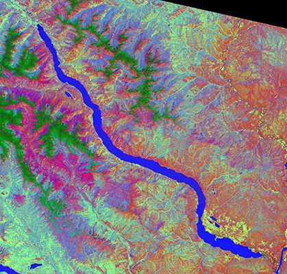
This Virtual Issue’s image is from the prize-winning poster by Neal Gallagher. It is a subset of a Landsat 8 image of Lake Chelan, WA (US Geological Survey, FILE_DATE = 2017-06-30T11:25:51Z). The selected image was 2050 × 2150 and included eight bands measured at a 30 m resolution: Bands 1 to 7 plus Band 9. Lake Chelan is in north central Washington, USA and is 50.5 miles long and 1486 ft deep. Principal components analysis was performed on the image spectra after normalising to a 1-norm and mean-centring. The figure shows a scores image (principal components 1, 2 and 3 = RGB, respectively) with the image auto-contrasted (the scores were mean-centred and scaled to lie between ±2 standard deviations). Analysis was performed using MATLAB (9.3 R2017b) [The MathWorks, Inc., Natick, MA], PLS_Toolbox (8.5) and MIA_Toolbox (3.0.5) [Eigenvector Research, Inc., Manson, WA] on Mac OS X.